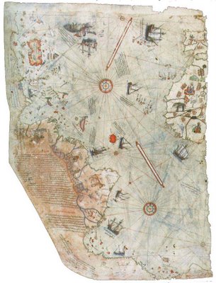
Piri Reis Map

Most everyone is somewhat familiar with the shape of Antartica on modern day maps. What many people may not realize is that the actual landmass of Antartica is much smaller and hidden beneath the great ice shelfs that define the continent on present maps. This landmass has been mapped by modern cartographers only recently using satellite technology.
The Piri Reis map, made in 1513 and discovered in 1929, defines that same, hidden landmass of Antartica. Unbelievably, it has been mapped with laser-like precision. Its accuracy has been compared with modern maps and the measurements are virtually identical. How did a sixteenth century mapmaker, with no twentieth century technology, create such an accurate representation, 300 years before the continent was even discovered?


3 Comments:
I'll definitely be addressing all those questions in the future. i wish i knew where all the sasquatches were hiding, too--in fact, i was considering going on an expedition sponsored by the Bigfoot Field Research Expedition (BFRO) to find one myself. Click on the Sasquatch link to learn more from BFRO.
I'd like to know the story behind Lake Tahoe. What other info do you have?
whoa, the Cousteau comment is disturbing. I didn't know about that. I did read an article about the temperature at the bottom of the lake and how it prevents bacteria from decomposing the bodies. But what else is down there? What do you think Cousteau saw?
I first came across this map in Graham Hancock's Fingerprints of the Gods. It's also printed in Maps of the Ancient Sea Kings.
Post a Comment
<< Home